Overview
Artemis processes and digitally enriches historical maps from before 1880, focusing on the Scheldt River Valley connecting Antwerp to Ghent. Using state-of-the-art extraction techniques, we enable research in Historical Geography, Ecology, and Spatial Planning through a IIIF-enabled Linked Open Data Research Infrastructure.
Public website: scheldegemapt.be
Abstract
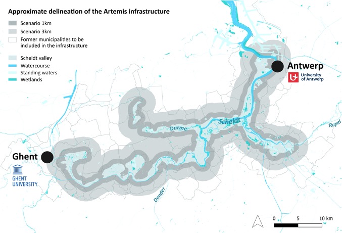
Historical maps are not only unique heritage objects but also containers of precious data on the evolution of the cultural and natural landscape. From the 16th century onwards, in present-day Belgium, handwritten local maps were produced in great numbers, followed by the famous Ferraris and printed Vandermaelen map series, as well as large numbers of large or medium scale cadastral maps. What is left of this unique heritage is dispersed over public and private collections, making users of digital historical maps struggle to use these maps to their full potential. Artemis is convinced that this wealth of detailed maps and map series has great potential to investigate landscapes, their evolution over time and their possible future(s) - a potential that could be used in varying fields of research such as Historical Geography, Ecology (biodiversity and water management) and Spatial Planning. Artemis aims to process, digitally enrich, make available and valorize well-defined corpora of both handwritten and printed maps before ca. 1880, using state of the art extraction techniques - as automated localization, toponym recognition and (landscape) feature extraction - with in finality, publication in a IIIF-enabled Linked Open Data Research Infrastructure, using Allmaps and Madoc. The project joins forces of both the University of Antwerp and Ghent University, backed up by the main Belgian map collection holders (ARA/KBR/NGI), focussing on the Scheldt River Valley which connects Antwerp to Ghent.
Team
Ghent University
- Prof. dr. Christophe Verbruggen (GhentCDH, supervisor)
- Prof. dr. Steven Verstockt (IDLab, co-supervisor)
- Dr. Kenzo Milleville (IDLab, automated processing)
- Vincent Ducatteeuw (GhentCDH, project coordinator)
- Rein Debrulle (GhentCDH, GIS)
- Frederic Lamsens (GhentCDH, IIIF developer)
- Fien Danniau (GhentCDH, digital heritage)
University of Antwerp
- Prof. dr. Iason Jongepier (supervisor)
- Dr. Léa Hermenault (co-supervisor)
Advisory Board
At Ghent University, this project brings together digital, historical, cartographic and geographical expertise. IMEC's IDLab (co-supervisor prof. dr. Steven Verstockt and dr. Kenzo Milleville) offers essential components in automated map enrichment. GhentCDH facilitates digitally enabled research in the Arts and Humanities, focusing on digital text analysis, image processing (with IDLab) and Linked Open Data.
The Geography Department (Landscape Research Unit, co-supervisor prof. dr. Veerle Van Eetvelde) brings interdisciplinary expertise in understanding landscapes from an ecological and spatiotemporal perspective using historical maps and GIScience tools. UGent's History Department contributes expertise in the history of science and environmental history (prof. dr. Thijs Lambrecht).
The UGent Quetelet Center for Quantitative Historical Research (prof. dr. Isabelle Devos) provides large-scale databases containing unique data about agriculture and spatial planning in Belgian history. By combining research interests of environmental historians with expertise from ForNaLab ecologists (prof. dr. Lander Baeten), Artemis will uncover landscape dynamics and ecological change.
Cultural Heritage Partners
- Belgian State Archives (ARA)
- Royal Library of Belgium (KBR)
- National Geographic Institute (NGI)
- Meise Botanic Garden

CLARIAH-VL services used in infrastructure pipeline Artemis project.


